Daniel B. Davis, Kentucky Transportation Cabinet, Division of Environmental Analysis
People are often surprised to learn that Kentucky has more than 20,000 recorded archaeological sites and probably far more sites that are unrecorded. However, as archaeological sites can be any location where people have lived that is at least fifty years old, and we know that people have lived in Kentucky for thousands of years, it’s really somewhat surprising that we don’t have more recorded sites! The relatively limited number of known sites is really more a reflection of the fact that intensive archaeological investigations have been conducted in Kentucky for less than a century, and most of those investigations have only been in the last 40 years.
Because of the number and size of Kentucky Transportation Cabinet (KYTC) projects across the state, the Cabinet is typically responsible for conducting a greater number of archaeological investigations than any other agency in Kentucky. The Kentucky Transportation Cabinet (KYTC) is committed to protecting and preserving Kentucky’s past, and we hope to highlight some of our dedication to these resources through this web page. This commitment is aided by the dedication of KYTC’s archaeological staff in the Division of Environmental Analysis. KYTC’s archaeological staff reviews nearly every highway project to determine if the project could impact archaeological resources and are responsible for maintaining the Cabinet’s compliance with various state and federal laws on historic preservation.
The Division of Environmental Analysis can be found at the Transportation Cabinet Building located at 200 Mero Street, in Frankfort, Kentucky. KYTC-DEA employs three archaeologists to oversee all aspects of transportation-related archaeological investigations in the state. Each archaeologist is responsible for four of the state’s 12 highway districts and their responsibilities include archaeological project management, review, agency coordination, and fieldwork.
Dan Davis: Cultural Resource Branch Manager, and Districts 1, 2, 9, and 12
Susan Neumeyer: Districts 4, 5, 10, and 11
Carl Shields: Districts 3, 6, 7, and 8
Consultants to the Cabinet complete most large-scale transportation-related archaeological investigations. KYTC archaeological staff conduct survey level work of small-scale projects, write agreements between Federal and state agencies to resolve impacts to significant archaeological sites, develop scopes of work specific to each project, monitor the work of the Cabinet’s consultants, and review submitted archaeological reports to ensure that high quality work is being performed.
How the Process Works
For projects with federal funding or permits, an environmental study is required to assess the potential for the project to impact or destroy archaeological resources. The starting point for federal projects is often an overview to determine what sites may already have been identified in a project area, followed by a Phase I survey to look for any unidentified archaeological sites. For projects with state funding, an assessment of the project to impact archaeological sites is made to determine if a survey will be required or if archaeological sites have already been recorded in the project’s path.
Overview – Assessment of Potential
The first step in assessing the potential of a project to impact archaeological sites is determining if any sites have previously been identified in the project area, or if the area has been previously surveyed. Once this determination has been made, archaeologists must consider whether the project has new right-of-way and if recent construction or other activities have disturbed the area. Using previous surveys and recorded site location data, archaeologists must try to understand the probability that a given area may contain archaeological sites. Historic maps and documents may be utilized to try and find any potential historic archaeological sites in a project area. Based on an assessment of the potential of an area to contain archaeological sites, recommendations for further work can be made.
Phase I – Survey and Site Discovery
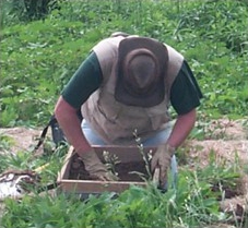
Archaeological survey is the examination of a project area to try and locate any archaeological sites that may be within the project’s footprint. Survey is completed by walking over areas with good visibility, such as plowed fields, or digging shovel probes at regular intervals in areas of poor visibility, such as overgrown fields. All dirt from the probes will be pushed through a screen to recover any artifacts that may be present. If a site contains few artifacts, cannot be dated on the basis of the recovered artifacts, or has been disturbed so that all of the soils containing artifacts have been mixed, no additional work will be required. If there are numerous artifacts, the age of the site can be determined through the recovered artifacts, or archaeologists find evidence of buried features, a Phase II evaluation may be required.
Phase II – Site Evaluation
Phase II excavations are done to find out if a site is eligible for nomination to the National Register of Historic Places (NRHP). Evaluations may include hand-excavated test units, large-scale excavation using mechanical equipment, the use of specialized scientific equipment such as ground-penetrating radar, and extensive research of archival documents. At the Phase II evaluation, archaeologists are trying to find out how much of the site has not been disturbed and how much we can learn from the site. If there are large numbers of artifacts and features, or if the site has not been disturbed by construction or erosion, the site may contain unique information that may tell us a great deal about the people that lived there. Sites that contain unique information may be considered significant, which makes them eligible for nomination to the NRHP. If a site is eligible, the impact can be offset by expanding our investigation to learn as much as possible from the site prior to its destruction.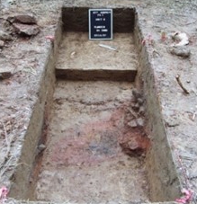
Phase III – Mitigation of Adverse Effect
If a site is eligible for nomination to the NRHP, it should be avoided by redesign of the project, if possible. If it is not possible to avoid the site, data recovery excavations must take place to mitigate the adverse effect to the site. Excavation strategies must include a detailed strategy that tells what we want to learn from the site and how to best accomplish the goal of recovery. Data recovery plans must be approved by the SHPO and the Advisory Council for Historic Preservation (ACHP) must be given the opportunity to comment on the plan. Site mitigation plans must also include an educational component that may include booklets, pamphlets, brochures, videos, or K-12 lesson plans developed for use with Project Archaeology.
KYTC Archaeology Web Page
Last, but not least, I invite you to explore the KYTC Archaeology page dedicated to some of the archaeological investigations we’ve undertaken through the years. Our site has a calendar of select archaeological events and conferences, resource links for archaeology in Kentucky and beyond, and videos completed as mitigation for effects to significant archaeological sites. Take a break and watch our fantastic video about Davis Bottom or a film about historic period archaeology in Kentucky dubbed Beneath Kentucky’s Fields and Streets, developed as alternative mitigation for sites along Covington’s 12th Street. We have a Heritage Spotlight series that covers specifics aspects of our state’s archaeology, such as the historic Maysville Road, early inns and homes along Maysville Road, and the Adena, the Woodland Period Moundbuilders of the Bluegrass. We have brief highlights of other sites excavated in the recent past, such as the Armstrong Farmstead, McConnell’s Farmstead, and Phase III Data Recovery at 15BH212. Our web page also maintains a growing collection of archaeological sites reports archaeological site reports – with specific locations deleted to protect the archaeological resources. Oh, and don’t forget to visit one of my favorites – Teaching Through Documentary Art! Stop by, look around, share, and pass along to any school teachers you know who may want to hear about some cool ideas, subjects, and lesson plans!